
Local Food Infrastructure
Fostering collaboration within local food value chains in NC by creating a robust food system infrastructure map

Working Groups
Task Force Goal
To map local food businesses and programs that serve as intermediary steps in the supply chain. *This map does not include farms or restaurants, though there is interest in developing a companion resource.
Contact co-coordinators Jennifer Bedrosian (jbedrosian@ptrc.org) or Ali Stone (alstone3@ncsu.edu) to get involved.
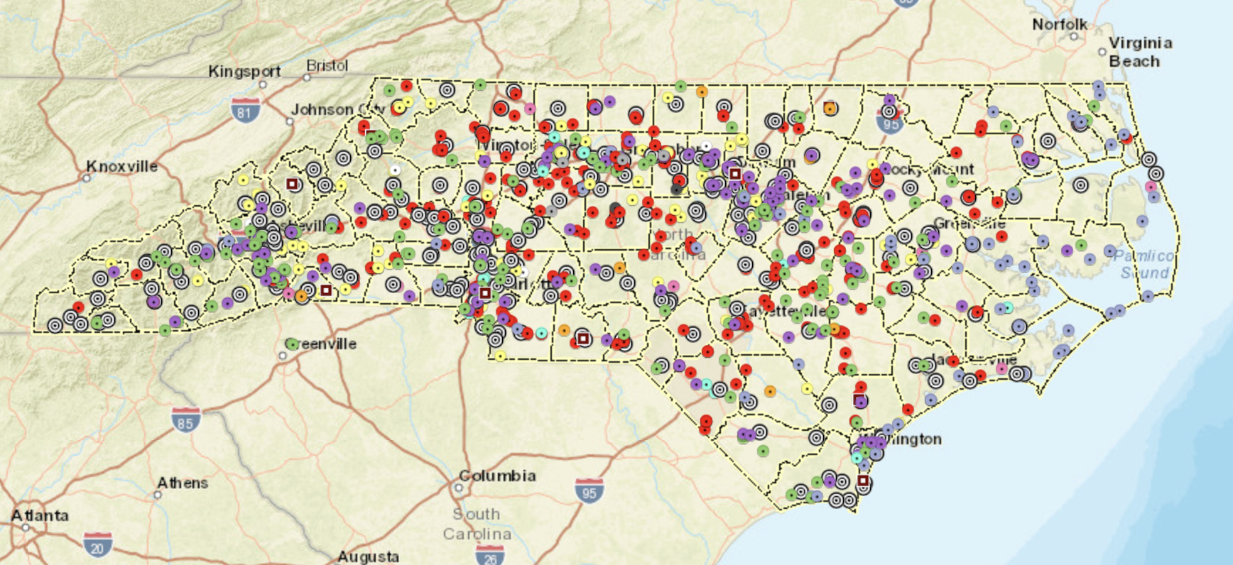
NC Local Food Infrastructure Inventory Map
In 2017, Piedmont Triad Regional Council partnered with NC Cooperative Extension on the North Carolina Growing Together Project that included a mapped inventory of businesses that serve as intermediary steps in the supply chain. Funding for the project ended in 2017; however, PTRC continues to receive requests for updated mapping data.
For 2 years, Community Food Strategies had convened a group of community leaders engaged in regional food assessment work in NC to share lessons learned. This group shifted into discussing creation of a statewide mapping resource to streamline resources.
In Fall 2022, the group issued a survey to gauge the desirability and feasibility of creating a resource. Over 50 responses across the state, comprehensive representation from across NC geographies, employment and roles.
Key survey takeaways: single landing page with searchable directory and downloadable data; county breakdown; easy to navigate; policy/advocacy; food assessment resources (KBR did this). Challenges for updating information were identified.
In early 2024, NCLFC began to facilitate an advisory group that was interested in moving the Local Food Infrastructure mapping project forward; which, combined efforts of people that were previously involved with the regional food assessment work. We currently meet quarterly to stay connected and provide updates. We are actively looking for funding this project.

The purpose of an updated local food infrastructure map would be to foster collaboration within local food value chains in NC that utilizes a community-based approach to data collection. Technical assistance trainings, workshops, and peer learning visits further enhance the usability of the project and help organizations identify and leverage assets that improve economic vitality and local food value chains across the state.
Increase partnerships and transactions between local growers/farmers and food hubs, food banks*, food pantries*, box programs*, food RX*, and/or institutions*. (*new update from previous map)
Inform investment decisions and policies that leverage assets, improve economic vitality, and strengthen community health, wealth, and resilience.
Identify challenges and gaps in infrastructure for small farms and mid-tier value chains.
Facilitate urban/rural connections in the food space (ex. cross-docking opportunities)
Identify resources and provide technical assistance, trainings, workshops, and peer learnings.
Community organizations, non-profits, Local food councils, and advocates working in the food space
Elected officials, local government, and Councils of Governments
Food Retail, food enterprises, and small to mid-sized farms
Visually pleasing design with updates and added categories (ex. micro-infrastructure like egg washing stations, box programs, cold storage at all levels)
Robust data collection with community geography approach: stipends to partner organizations across the state already collecting data or poised to do so
Add context to understanding how elements connect to the broad food system sectors and provide resources through technical assistance trainings, workshops, and peer learning
Marketing and communication, including a map listserv, to make website user friendly and share out information
Develop maintenance schedule for updates
Sustainability plan for long term funding support
Seeking Funding for a Statewide Local Food Infrastructure Map Update
Purpose
Goals
Primary Audience
Deliverables
Resources
ASAP Local Food Guide
Appalachian Sustainable Agriculture Project
ASAP’s annual Local Food Guide is the definitive resource for finding local food and farms throughout the Appalachian Grown region. Each year ASAP staff connects with markets, farms, and businesses to update listings, offering the most accurate information for consumers.
Categories Featured: Brick & Mortar Food Retail (including grocery, coops, dollar stores), Dairy Processing/Cheese, Farmers’ Markets, Fruit and Vegetable Delivery Services, Fruit and Vegetable Wholesale/ Distribution, and more.
Counties Featured: Alleghany, Ashe, Avery, Buncombe, Burke, Caldwell, Cherokee, Clay, Graham, Haywood, Henderson, Jackson, Macon, Madison, McDowell, Mitchell, Polk, Rutherford, Swain, Transylvania, Watauga, Wilkes, Yancey
Food Finder
Greater High Point Food Alliance
Search food resources closest to you throughout High Point and Greensboro North Carolina. View hours, contact information, and any details.
Categories Featured: Farmers’ Markets, Food Pantries, Institutions (hospitals, schools, colleges/universities), and more.
Counties Featured: Guilford
Healthy Food Access Mapping Project
Upper Coastal Plains Council of Government
Creates deep transparency into the Upper Coastal Plain region's local, healthy food systems.
Categories Featured: Aggregation, Brick & Mortar Food Retail (including grocery, coops, dollar stores), Dairy Processing/Cheese, Farmers’ Markets, Food Pantries, Fruit and Vegetable Delivery Service, Fruit and Vegetable Processing, Fruit and Vegetable Wholesale/ Distribution, Gristmills, Meat Processing, Seafood Processing or Wholesale Distribution, and more.
Counties Featured: Edgecombe, Halifax, Nash, Northampton, Wilson
Resource Mapping
Tri-COG F.E.E.D.S. (Food Ecosystem Economic Development Strategy)
A recurring theme across the engagement sessions hosted as part of the Tri-COG FEEDS project was a need for a centralized and living space entailing the region's assets. We've pulled together more than 1200 locations of farms and gardens, farmers markets, food infrastructure, emergency food resources, and restaurants and retailers that purchase locally to be used by both producers and consumers.
Categories Featured: Aggregation, Brick & Mortar Food Retail (including grocery, coops, dollar stores), Cold Storage- all levels, Commercial Kitchen/Co-packer, Dairy Processing/Cheese, Farmers’ Markets, Food Pantries, Fruit and Vegetable Processing, Fruit and Vegetable Wholesale/ Distribution, Institutions (hospitals, schools, colleges/universities, Meat Processing, Seafood Processing or Wholesale Distribution, and more.
Counties Featured: Alamance, Chatham, Durham, Edgecombe, Franklin, Granville, Halifax, Johnston, Lee, Moore, Orange, Nash, Northampton, Person, Vance, Wake, Warren, Wilson
WNC Food Resource Map
WNC Food Systems Coalition
The purpose of the WNC Food Resources Map is to show the food system assets of 18 counties and the Eastern Band of Cherokee Indians in western North Carolina.
Categories Featured: Aggregation, Brick & Mortar Food Retail (including grocery, coops, dollar stores), Commercial Kitchen/Co-packer- all levels, Compost Program, Dairy Processing/Cheese, Farmers’ Markets, Food Pantries, Fruit and Vegetable Processing, Fruit and Vegetable Wholesale/ Distribution, Meat Processing, and more.
Counties Featured: Avery, Buncombe, Burke, Cherokee, Clay, Graham, Haywood, Henderson, Jackson, Macon, Madison, McDowell, Mitchell, Polk, the Qualla Boundary, Rutherford, Swain, Transylvania, Yancey